Human Induced Erosion Cycles near the Port Town of Progreso in the State of
Yucatan, Mexico
Klaus Meyer-Arendt
The University of West Florida
Department of Environmental Studies
11000 University Parkway
Pensacola, FL 32514

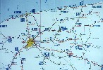
 Map showing major cities of Mexico. The following images were taken near the cities of Progreso and Mérida.
 Northern portion of the Mexican state of Yucatán, including capital of Mérida, population ca. 700,000.
 The Yucatán platform dips gently northward, and a barrier/ lagoon system characterizes the coastal environment. The shoreline is sand/shell,
longshore transport is from east to west, and isolated limestone outliers account for small 'headlands'.
The Yucatán platform dips gently northward, and a barrier/ lagoon system characterizes the coastal environment. The shoreline is sand/shell,
longshore transport is from east to west, and isolated limestone outliers account for small 'headlands'.
 A satellite shot shows the transition from upland to wetland and lagoon and barrier. In the center is visible the main highway from Mérida
due north to the port town of Progreso.
A satellite shot shows the transition from upland to wetland and lagoon and barrier. In the center is visible the main highway from Mérida
due north to the port town of Progreso.
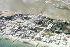
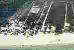
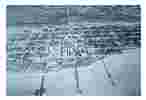 Progreso became an important port town during the late 19th-century henequen (sisal) boom. A rail line from Mérida extended out to long wharfs.
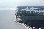
 Shorefront engineering in the early to mid-20th century led to extensive shoreline erosion west (downdrift) of the port.
 In 1968, a safe harbor (Yucalpetén) was dredged just west of Progreso. Jetties helped maintain the channel, but quickly updrift accretion and
downdrift erosion resulted.
In 1968, a safe harbor (Yucalpetén) was dredged just west of Progreso. Jetties helped maintain the channel, but quickly updrift accretion and
downdrift erosion resulted.
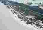
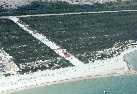
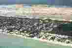
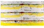 The entire north coast is popular for tourism development, and this map sequence shows how traditional fishing villages have now coalesced into
contiguous beachfront communities. The 'frontier' or recreational development is east of Progreso.
The entire north coast is popular for tourism development, and this map sequence shows how traditional fishing villages have now coalesced into
contiguous beachfront communities. The 'frontier' or recreational development is east of Progreso.
 As this newspaper photo shows, the shorefront east of Progreso is relatively natural and esthetically pleasing whereas west of Progreso,
groin-building and erosion characterize the landscape.
As this newspaper photo shows, the shorefront east of Progreso is relatively natural and esthetically pleasing whereas west of Progreso,
groin-building and erosion characterize the landscape.
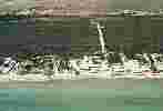
 The former fishing village of Chelem is now fronted with vacation homes a 5-mile-long groin field. Groin (espigón or espolón) construction began
downdrift of the Yucalpetén jetties in 1968 and incrementally shifted westward until the mid-1980s.
The former fishing village of Chelem is now fronted with vacation homes a 5-mile-long groin field. Groin (espigón or espolón) construction began
downdrift of the Yucalpetén jetties in 1968 and incrementally shifted westward until the mid-1980s.
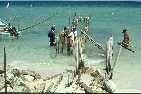 Although now technically illegal without a permit, groin construction continues. Palm or tree trunks are 'jetted' several feet into the
sand to create a framework, the limestone rocks are used to fill in the groin.
Although now technically illegal without a permit, groin construction continues. Palm or tree trunks are 'jetted' several feet into the
sand to create a framework, the limestone rocks are used to fill in the groin.
 As shown here, the sand-trapping effects of a groin are seen within weeks.
 Sometimes groins are connected with 'breakwaters', although any benefits of such construction are yet to be seen.
 Esthetically, the resultant shoreline leaves much to be desired. Also, the groins and other structures weren't very effective, in part because of
lack of engineering and in part because of a paucity of longshore sediments.
Esthetically, the resultant shoreline leaves much to be desired. Also, the groins and other structures weren't very effective, in part because of
lack of engineering and in part because of a paucity of longshore sediments.
 Near the western distal end of the groins, near the village of Chuburná Puerto, local authorities claim that there was no erosion until the groins
moved in, and they are now banned from this political jurisdiction.
Near the western distal end of the groins, near the village of Chuburná Puerto, local authorities claim that there was no erosion until the groins
moved in, and they are now banned from this political jurisdiction.
 During cold fronts and summer storms (including Hurricane Juan in 1985, seen here), the beach frequently disappeared, and considerable undermining
of structures took place.
During cold fronts and summer storms (including Hurricane Juan in 1985, seen here), the beach frequently disappeared, and considerable undermining
of structures took place.
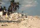 Several homeowners built private 'seawalls' to guard against frequent erosional activity, but Hurricane Gilbert in 1988 proved to be too strong.
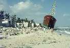 Even freighters couldn't outrun Gilbert, but at least it offered some protection to a few vacation homes in its lee.
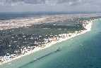
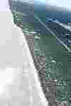 East of Progreso, the shoreline has been relatively pristine. The numerous beach ridges also made the barrier less vulnerable to breaching during hurricanes.
 Offshore Pleistocene limestone outliers often led to formation of tombolos or headlands, where the shoreline remained relatively stable. Downdrift of such
headlands, erosion and accretion frequently alternated.
Offshore Pleistocene limestone outliers often led to formation of tombolos or headlands, where the shoreline remained relatively stable. Downdrift of such
headlands, erosion and accretion frequently alternated.
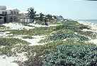 Much of the development in this area was more upscale, and the better-educated homeowners built their homes well behind the primary dunes.
 In some of the older fishing villages such as Chicxulub Puerto, proximity to the sea soon led to a threat of erosion and construction of groins.
 In 1994, there was quite of bit of short-groin-building underway in Chicxulub Puerto.
 East of Chicxulub Puerto, there were no groins at all prior to the 1990s (the San Miguel coconut grove is shown in the foreground).
 Just west (downdrift) of San Miguel, the beach was relatively wide--allegedly in part because of a long groin that had been illegally constructed
and was now covered with sand.
Just west (downdrift) of San Miguel, the beach was relatively wide--allegedly in part because of a long groin that had been illegally constructed
and was now covered with sand.
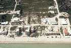
 A little further westward lay the subdivision of Diana Milán (shown here in 1985), where many of the middle-class homeowners had built on top of
the primary dunes.
A little further westward lay the subdivision of Diana Milán (shown here in 1985), where many of the middle-class homeowners had built on top of
the primary dunes.
 By 1994, Diana Milán had experienced 2-3 m of erosion, and homeowners had begun to build groins on a piecemeal basis.
 Downdrift erosion soon forced other homeowners to follow suit.
 In response, the locus of erosion shifted further westward, and soon upper-class properties were being armored with groins.
 Even sandbag groins were experimented with in the mid-1990s. Historically, there has been fluctuation in the location of the shoreline.
But as groins are built to combat the problem, erosion become a more permanent part of coastal processes.
Even sandbag groins were experimented with in the mid-1990s. Historically, there has been fluctuation in the location of the shoreline.
But as groins are built to combat the problem, erosion become a more permanent part of coastal processes.
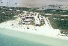 East of Progreso, there never was any port-induced erosion, and no one had to build groins to respond to such erosion. If new developments,
such as this hotel, build back far enough, there will never be need to alter the shorefront.
East of Progreso, there never was any port-induced erosion, and no one had to build groins to respond to such erosion. If new developments,
such as this hotel, build back far enough, there will never be need to alter the shorefront.
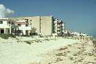 However, if construction removes the primary dunes, small storms will soon allow waves to reach the toes of the foundations.
 This will lead to calls for building groins, and a human-induced erosional cycle will begin anew.
 There is still much relatively undeveloped property east of Progreso, but whether it will be converted to a west-of-Progreso landscape is
still too early to tell.
There is still much relatively undeveloped property east of Progreso, but whether it will be converted to a west-of-Progreso landscape is
still too early to tell.
 The end.
Return to the Table of Contents